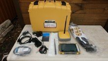

Topcon HiPer VR GNSS Receiver
The Topcon HiPer VR is a compact lightweight integrated GNSS receiver for surveying and construction layout. It packs an advanced GNSS chipset a full wave antenna, radios, and a built in tilt sensor into a rugged housing and works as a network rover a jobsite RTK rover or base or a post processing static receiver. Topcon positions it as the more compact higher featured successor to earlier HiPer receivers.
Key Features HiPer VR
- Universal Tracking Channels: 226 channels using Topcon patented technology, tracking GPS, GLONASS, Galileo, BeiDou, IRNSS (NavIC), QZSS, and SBAS signals including the modernized signals with two channels reserved for L-band
- TILT technology: Topcon Integrated Leveling Technology uses a 9-axis inertial measurement unit (IMU) and a 3-axis eCompass to compensate for a pole that is out of plumb by as much as 15° (subject to successful tilt calibration and an environment free of magnetic disturbances)
- Fence Antenna technology: a full wave antenna with an internal ground plane designed for strong signal lock and signal scrubbing
- High-accuracy positioning: typical specified accuracy of 5 mm + 0.5 ppm horizontal and 10 mm + 0.8 ppm vertical in RTK with Static and Precision Static modes improving on that
- Tilt-compensated RTK: horizontal accuracy of about 1.3 mm per degree of tilt up to 10°
- Code differential accuracy: under 0.25 m horizontal and under 0.50 m vertical
- Integrated radios: a 400 MHz UHF transmit/receive radio modem, and a license free 900 MHz radio modem using the FH915 protocol
- LongLink: interference free communication for long range jobsite links
- Flexible operation: static or kinematic post processed surveys, network RTK rover (using the controller internal 4G/LTE modem) and UHF, FH, or LongLink jobsite RTK rover
- Hybrid Positioning: works with Topcon patented workflow combining GNSS with total station measurements
- L-band ready: able to receive advanced correction services globally (contact Topcon about availability)
- Rugged build: IP67 rated with a rugged housing instead of weak plastic ready for the job site
- Compact form factor: suited to millimeter GPS and hybrid positioning setups
Typical Applications
- Topographic, boundary, and control surveys
- Construction layout and stakeout
- Network RTK and jobsite RTK surveys
- Static and post processed surveys
- Hybrid GNSS and total station workflows
Why Choose It
The HiPer VR delivers high accuracy GNSS and tilt compensated measurement in a compact rugged receiver with integrated radios. It lets crews speed up stakeout and reduce time spent leveling the pole while multi constellation tracking keeps it ready for the future.